Trail Walking La Vernaz - Pont du Diable - La Touvière - Lac du Jotty - Photo

Pont du Diable - La Touvière - Lac du Jotty

 Kargil
Kargil

User GUIDE

© OpenStreetMap contributors
Length
Length
16.8 km
Max alt
Max alt
1299 m
Uphill gradient
Uphill gradient
917 m
Km-Effort
Km-Effort  
29 km
Min alt
Min alt
638 m
Downhill gradient
Downhill gradient
918 m
Boucle
Boucle
Yes
Creation date :
2021-10-19 07:36:11.365
Updated on :
2021-10-20 10:18:52.022

(0 Reviews)

Walking
Walking
4h49
Difficulty : Difficult

Scan this QR Code to open this trail in the SityTrail application

FREE GPS app for hiking

Logo SityTrail SityTrail

IGN / Geographical institutes

Download SityTrail from the App Store Download SityTrail from Google Play

Logo SityTrail SityTrail World

The world is yours!

Download SityTrail from the App Store Download SityTrail from Google Play Download SityTrail on Huawei AppGallery

About

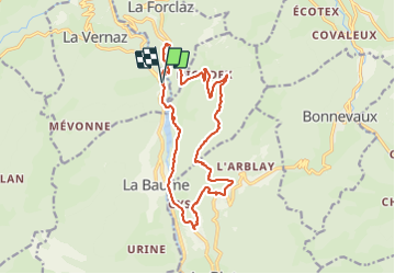
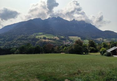
Trail Walking of 16.8 km to be discovered at Auvergne-Rhône-Alpes, Upper Savoy, La Vernaz. This trail is proposed by Kargil.

Description

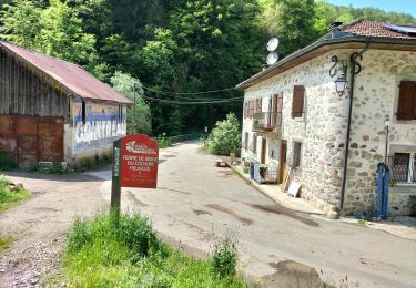
Le départ est un peu laborieux entre les aménagements touristiques des gorges et les sentiers labourés par l'exploitation forestière vers Le Cruet.
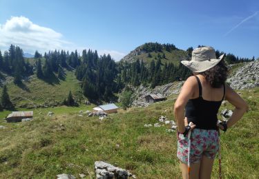
Puis une première partie en traversée peu entretenue et donc très sauvage.
Le sentier est constamment en dévers et assez exposé. Il nécessite donc de l'attention et il est à déconseiller par temps de pluie et par des randonneurs peu expérimentés ou sujet au vertige.
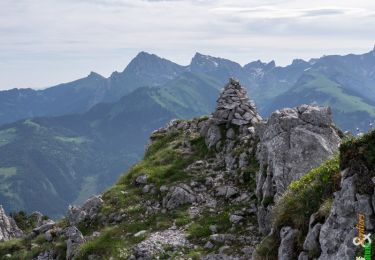
Le Passage de l'Ours est très bien protégé et ne présente aucune difficulté.

Elevation profile

Photos

Positioning

Country:
France
Region :
Auvergne-Rhône-Alpes
Department/Province :
Upper Savoy
Municipality :
La Vernaz
Location:
Unknown
Start:(UTM)
316364 ; 5130720 (32T) N.

Trails nearby

Trail Walking Vailly - Pointe d'Ireuse par les Nifflons - Photo
Walking
christophe7406

Walking

Difficult
(1)
Vailly, Auvergne-Rhône-Alpes, Upper Savoy, France
8.5 km | 16.9 km-effort
4h 0min
Yes
Trail Walking Le Biot - La Pointe de la Croix depuis le Biot - Photo
Walking
thierry13710

Walking

Medium
Le Biot, Auvergne-Rhône-Alpes, Upper Savoy, France
19.3 km | 34 km-effort
7h 2min
Yes
Trail Walking La Forclaz - col de tréchaussée - Photo
Walking
jntoreau

Walking

Medium
La Forclaz, Auvergne-Rhône-Alpes, Upper Savoy, France
6.6 km | 12.2 km-effort
2h 15min
Yes
Trail Walking Reyvroz - rochers de la garde, chalets de Perthuis au départ du pont de Bioge - Photo
Walking
reneperrin

Walking

Difficult
Reyvroz, Auvergne-Rhône-Alpes, Upper Savoy, France
17.1 km | 33 km-effort
6h 55min
Yes
Trail Walking Vailly - ireuse - Photo
Walking
PierreBellevaux

Walking

Very easy
Vailly, Auvergne-Rhône-Alpes, Upper Savoy, France
6.8 km | 13.1 km-effort
2h 31min
Yes
Trail Walking La Forclaz - La Pointe de Tréchauffex 1627 m, traversée depuis la Forclaz - Photo
Walking
tracegps

Walking

Medium
La Forclaz, Auvergne-Rhône-Alpes, Upper Savoy, France
5.9 km | 11.2 km-effort
2h 30min
Yes
Trail Walking Le Biot - Le Mont Ouzon 1880 m, depuis le Col du Corbier - Photo
Walking
tracegps

Walking

Difficult
Le Biot, Auvergne-Rhône-Alpes, Upper Savoy, France
6.2 km | 14.4 km-effort
3h 30min
Yes
Trail Walking Vailly - Par Reyvroz - Photo
Walking
bopapa

Walking

Medium
Vailly, Auvergne-Rhône-Alpes, Upper Savoy, France
5.4 km | 7.6 km-effort
1h 43min
Yes
Trail Electric bike Chevenoz - tour du barron et des memises - Photo
Electric bike
desu

Electric bike

Medium
Chevenoz, Auvergne-Rhône-Alpes, Upper Savoy, France
31 km | 54 km-effort
3h 18min
No


Close
My subscriptions